
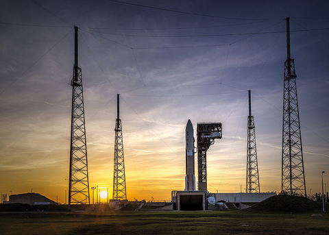
 CAPE CANAVERAL: This NASA photo released on March 1, 2018 shows the Geostationary Operational Environmental Satellite (GOES-S) as it sits on the launch pad at Space Launch Complex 41, Cape Canaveral Air Force Station. —AFP
MIAMI: A new US satellite that offers speedy, high-resolution images of storms and may save lives by making forecasts more accurate blasted off from a NASA launchpad. "Three, two, one and liftoff!" said a NASA commentator as the Atlas V rocket rumbled into the blue sky at 5:02 pm (2202 GMT) over Cape Canaveral Air Force Station in Florida, carrying the Geostationary Operational Environmental Satellite-S (GOES-S).
GOES-S is the latest in a series of advanced weather satellites owned by the National Oceanic and Atmospheric Administration (NOAA). Its predecessor, GOES-R, launched in November 2016 and has already helped improve forecasts of last year's monster hurricanes in the Atlantic and Caribbean, Harvey, Maria and Irma, experts say. Stephen Volz, director for satellite and information services at NOAA, said GOES-R has "revolutionized" the way people view weather and environmental information and the entire constellation presents "a quantum leap above" prior generations.
GOES-R, which was renamed GOES-16 upon reaching orbit, "it is already proving to be a game-changer with much more refined, higher quality data for faster, more accurate weather forecasts, warnings and alerts," Volz said. "This means quite frankly more lives are saved and better environmental information is made available for state and local officials who, for example, may need to make decisions about when to call for evacuations when life-threatening storms and wildfires occur." GOES-S will be renamed GOES-17 once it reaches space, and will "provide faster, more accurate data for tracking wildfires, tropical cyclones, fog and other storm systems and hazards that threaten the western United States, including Hawaii and Alaska, Mexico, Central America and the Pacific Ocean, all the way to New Zealand," NOAA said in a statement.
'Most sophisticated ever flown'
The satellite should help improve forecasts for storms forming in the Pacific, and allow experts to see storms churning in high resolution. The primary customer for the data from the GOES satellites is the US Weather Service, but the information they beam to Earth is also shared openly with meteorologists around the world, NOAA said. "These satellites are giving us the ability to look at storms as often as every 30 seconds, allowing forecasters to see storms as they are developing instead of as they have already taken place," said Tim Walsh, acting GOES-R system program director at NOAA.
"The advanced baseline imager, the ABI, is taking some of the most vivid pictures of weather, climate and oceans in the western hemisphere that we have ever seen," he added. After it launches, GOES-S will undergo six months of tests, then be operational late 2018. Two more are scheduled for launch in the coming years: GOES-T in 2020 and GOES-U 2024. "Coupled with the use of our Japanese partner's advanced Himawari satellite, we are able to cover more than half the planet with the most sophisticated weather forecast technology and observations ever flown from space," Volz said. - AFP


